GIS - Southern France Wildfire
 Image credit: NASA / JPL-CalTech / ECOSTRESS
NASA’s ECOSTRESS Wildfire Observation Featured on NASA Homepage
For over a month, NASA highlighted this ECOSTRESS product on its public homepage to recognize its value in real-time wildfire monitoring and international emergency response.
On August 6, 2025, the ECOSTRESS (ECOsystem Spaceborne Thermal Radiometer Experiment on Space Station) instrument acquired high-resolution thermal imagery of an active wildfire front in the Aude department of southern France. The imagery showed land surface temperatures during a peak growth phase of the fire, with values ranging from elevated background temperatures to very hot active-fire pixels.
Because ECOSTRESS can measure land surface temperature and plant stress from the International Space Station, these data were shared as a critical reference layer for the France Fire Department and regional incident teams. The product supported:
- Rapid assessment of where the fire was hottest
- Better understanding of fire behavior across mixed terrain
- Communication of fireline location and severity to decision makers
- Broader demonstration of space-based thermal data for disaster management
This feature also illustrated ECOSTRESS’s broader mission: using thermal imaging to track water stress, agricultural impacts, urban heat, and extreme events from space.
Why It Was Recognized
- Placed on the NASA homepage for >1 month as an example of actionable Earth-observing science
- Demonstrated ISS-based thermal sensing for an ongoing emergency, not just retrospective science
- Created in collaboration with NASA JPL, ECOSTRESS science team, and a student contributor from Arnold O. Beckman High School
Research Image
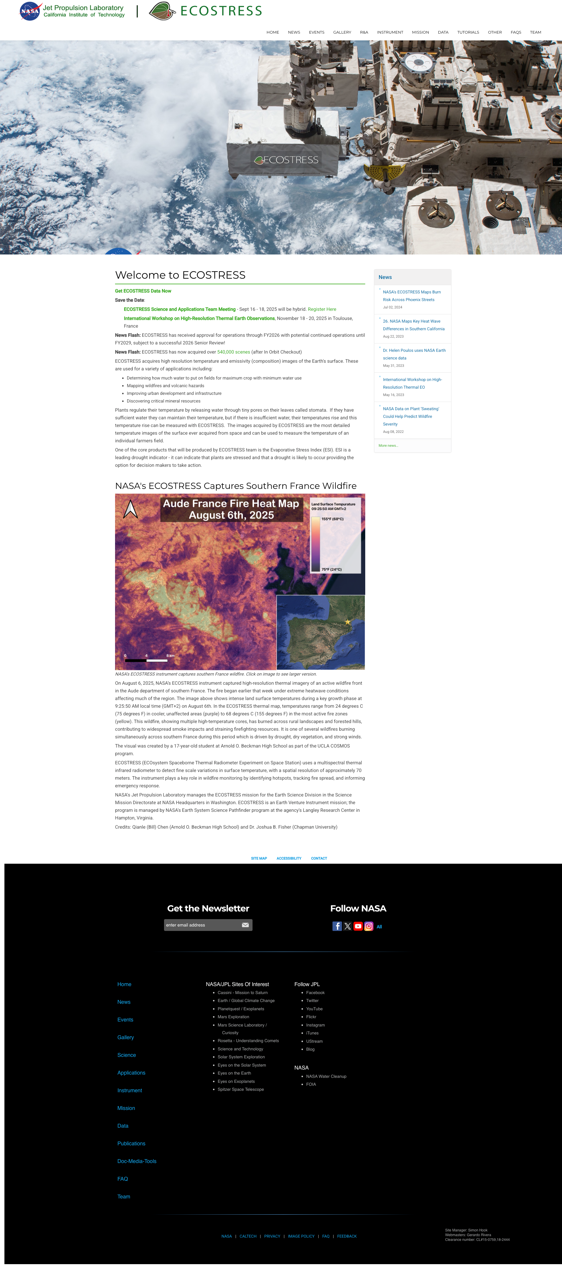
ECOSTRESS thermal map of the August 6, 2025 southern France wildfire, featured on the NASA homepage for over a month and used by France Fire Department as a situational layer. Image credit: NASA / JPL-Caltech / ECOSTRESS.